Art
Advertising
- Advertising
- Tin (Cassiterite) Distribution: Mediterranean Bronze Age
- Archaeological Sites of the Aegean Minoans
- Extent of Santorini Eruption's Tsunami Inundation of Minoan Crete
- End of Minoan Linear A Writing and LM IB Fire Destruction of Crete
-
The Cause of the End of the Bronze Age
with the Scientific Method -
Nature Geoscience Journal and
Late Minoan IB Destruction Event - Prehistoric Star Navigation, Eastern Mediterranean Ethnocentric Bias, and the "Cabal of Certainty"
- Theoretical Bronze Age Minoan Heliographic Aegean Network Validated by 92.15 Mile (148.3 Km) Mirror Sunlight Flashes
- The Validation of a Bronze Age Minoan Heliographic Aegean Network in Southern California
- Tsunami Generation from the Titanic Bronze Age Minoan Eruption of the Santorini Marine Volcano
- The Cento Camerelle Mines of Tuscany: A Major Bronze Age Source of Tin
- No Men or Sails Required: Successful Prehistoric Sea Travel
- Minoan Downfall and Volcanology's Black Hole of Unknowns
- Homer and Navigating by the Stars in Prehistory
- Primacy of Human Powered Rowing in Copper Age and Minoan Shipping
- Minoan Invention of the True Dome and Arch Prehistoric Mediterranean Catenary Architecture
- "Sinking Atlantis" Tsunami Myth Debunked
- Minoan Tholos Structural Mechanics and the Garlo Well Temple
- Minoan Web of Mirrors and Scripts
- Santorini Eruption and LM IB Destruction
- Minoan Catastrophe: Pyroclastic Surge Theory
- Early Minoan Colonization of Spain
- Origin of the Sea Peoples
- Minoan Ship Construction
- Minoan Maritime Navigation
- Ringed Islands of Thera, Santorini, Greece
- Minoan Scientific Tradition
GIS Google Earth
Publications
Publications
Official Art Gallery
A Collection of 20 Paintings each with over 70 Art Products
The Bronze Age eruption of Santorini (Thera) with a VEI (Volcanic Explosivity Index) of seven was one of the largest volcanic events in recorded history. At this time there was a terrible destruction of Minoan Crete that so weakened them that they were soon conquered by the Myceneans some decades later.
Minoan Miniature Frieze Admirals Flotilla Fresco
Shipping Scene Restoration
Late Bronze Age (LBA)
Neo-Palatial Late Minoan I Period
West House, Room 5, South Wall
Akrotiri, Santorini (Thera), Greece
Shipping Scene Restoration
Late Bronze Age (LBA)
Neo-Palatial Late Minoan I Period
West House, Room 5, South Wall
Akrotiri, Santorini (Thera), Greece
All sites are referenced to the scientific literature and have links to additional descriptive and visual information wherever possible with some exceptions. I want to express my great thanks for the kind generosity of all the contributors who are to be congratulated for making this possible. As always I would appreciate any additions, corrections, comments, or suggestions that anyone may have.
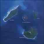
Minoan Depiction of the Ringed Islands of Thera
Minoan Miniature Frieze Admirals Flotilla Restoration Fresco
Late Bronze Age (LBA)
Neo-Palatial Late Minoan I Period
West House, Room 5, South Wall
Akrotiri, Santorini (Thera), Greece
Minoan Miniature Frieze Admirals Flotilla Restoration Fresco
Late Bronze Age (LBA)
Neo-Palatial Late Minoan I Period
West House, Room 5, South Wall
Akrotiri, Santorini (Thera), Greece
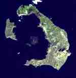
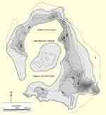
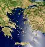
Over the years some have proposed that a huge tsunami(s) generated by the massive eruption was the primary cause for the destruction of Neo-Palatial Minoan Crete. This hypothesis assumes the great majority of the Minoan population lived on mountainous Crete's vulnerable low-lying northern and eastern coastal plains. When the tsunamis struck they decimated the Minoan population and left Crete essentially depopulated. In order to examine the veracity of this hypothesis two questions must be asked.
What does the archaeology say about the distribution of the Neo-Palatial Minoan population on Crete?
and
What is the maximum possible extent of tsunami run-up and inundation on the northern and eastern coasts of Minoan Crete?
In order to provide a solid foundation for the population distribution on Crete the Neo-Palatial archaeological sites listed in the Aegean Minoan 3D GIS Project are included in this mapping. The best tsunami model so far put forth for the Santorini eruption is from the 2008 publication:
Bruins, MacGillivray, Synolakis, Benjamini, Keller, Kisch, Klugel, and van der Plicht. "Geoarchaeological tsunami deposits at Palaikastro (Crete) and the Late Minoan IA eruption of Santorini", Journal of Archaeological Science 35, pp. 191-212, 2008.
It proposes that the tsunami produced at the volcano had a +35 to -15 meter initial amplitude and a crest length of about 15 km. By the time it reached the coastlines of Crete it would have, depending on the shape of the seafloor near the coast and other factors, had variable wave heights ranging from negligible to 26 meters (85.3 feet).
Computer modeling of the wave's runup on land is strewn with complexities making field work very important. No accurate mapping of the tsunami inundation of Minoan Crete has yet been published. As a reasonable alternative this mapping highlights the island's inland elevation contour of 40 meters (131 feet) above sea level along its northern and eastern coastlines. This should give a good indication of the maximum possible extent of penetration and destruction caused by a 26 meter high set of tsunamis. The 40 meter elevation contour line is nothing more than a crude, but reasonable, approximation of the maximum worst-case runup limit on such a wave's ability to flood the coasts of mountainous Crete. As soon as an accurate map of the Cretan inundation is published I will include it here.
Having effectively addressed the above two questions regarding the tsunami destruction theory, this mapping strongly contradicts it by conclusively showing there is absolutely no archaeological evidence for a large concentration of Minoan settlements in Crete's vulnerable coastal areas. In fact the pattern of archaeological sites shows that the population was distributed throughout most of inland Crete especially in the central and eastern regions. The urban centers of Knossos, Archanes, Phaistos, and many others were completely untouched! The great majority of the Minoan population would have survived any tsunami destruction from the Bronze Age eruption.
This is not the first time the tsunami theory has been refuted for its unfounded assumptions as the primary cause for the Minoan destruction.
Minoura, Imamura, Kuran, Nakamura, Papadopoulos, Takahashi, Yalciner. "Discovery of Minoan tsunami deposits", Geology, V. 28, No. 1, pp. 59-62, January 2000.
Whatever the true nature of the Minoan destruction was, the tsunamis produced by the Santorini eruption could only have been a relatively minor component of the overall event. It is time to move on from this deeply flawed and archaeologically unsustainable hypothesis and begin to more closely scrutinize other scientifically valid possibilities. One of which I proposed in a paper written for the Thera Foundation in 2007.
Another publication relevant to this subject was released earlier this year.
The hypothesis that a volcanic tsunami(s) was the primary cause for the destruction of Neo-Palatial Crete can only be supported in dreams that defy the laws of physics. I would sincerely appreciate any comments that anyone may have.
What does the archaeology say about the distribution of the Neo-Palatial Minoan population on Crete?
and
What is the maximum possible extent of tsunami run-up and inundation on the northern and eastern coasts of Minoan Crete?
In order to provide a solid foundation for the population distribution on Crete the Neo-Palatial archaeological sites listed in the Aegean Minoan 3D GIS Project are included in this mapping. The best tsunami model so far put forth for the Santorini eruption is from the 2008 publication:
Bruins, MacGillivray, Synolakis, Benjamini, Keller, Kisch, Klugel, and van der Plicht. "Geoarchaeological tsunami deposits at Palaikastro (Crete) and the Late Minoan IA eruption of Santorini", Journal of Archaeological Science 35, pp. 191-212, 2008.
It proposes that the tsunami produced at the volcano had a +35 to -15 meter initial amplitude and a crest length of about 15 km. By the time it reached the coastlines of Crete it would have, depending on the shape of the seafloor near the coast and other factors, had variable wave heights ranging from negligible to 26 meters (85.3 feet).
Computer modeling of the wave's runup on land is strewn with complexities making field work very important. No accurate mapping of the tsunami inundation of Minoan Crete has yet been published. As a reasonable alternative this mapping highlights the island's inland elevation contour of 40 meters (131 feet) above sea level along its northern and eastern coastlines. This should give a good indication of the maximum possible extent of penetration and destruction caused by a 26 meter high set of tsunamis. The 40 meter elevation contour line is nothing more than a crude, but reasonable, approximation of the maximum worst-case runup limit on such a wave's ability to flood the coasts of mountainous Crete. As soon as an accurate map of the Cretan inundation is published I will include it here.
Having effectively addressed the above two questions regarding the tsunami destruction theory, this mapping strongly contradicts it by conclusively showing there is absolutely no archaeological evidence for a large concentration of Minoan settlements in Crete's vulnerable coastal areas. In fact the pattern of archaeological sites shows that the population was distributed throughout most of inland Crete especially in the central and eastern regions. The urban centers of Knossos, Archanes, Phaistos, and many others were completely untouched! The great majority of the Minoan population would have survived any tsunami destruction from the Bronze Age eruption.
This is not the first time the tsunami theory has been refuted for its unfounded assumptions as the primary cause for the Minoan destruction.
Minoura, Imamura, Kuran, Nakamura, Papadopoulos, Takahashi, Yalciner. "Discovery of Minoan tsunami deposits", Geology, V. 28, No. 1, pp. 59-62, January 2000.
Whatever the true nature of the Minoan destruction was, the tsunamis produced by the Santorini eruption could only have been a relatively minor component of the overall event. It is time to move on from this deeply flawed and archaeologically unsustainable hypothesis and begin to more closely scrutinize other scientifically valid possibilities. One of which I proposed in a paper written for the Thera Foundation in 2007.
The Minoan Catastrophe: The Pyroclastic Surge Theory
Another publication relevant to this subject was released earlier this year.
The Bronze Age Eruption of Santorini and Late Minoan IB Destruction Event
The hypothesis that a volcanic tsunami(s) was the primary cause for the destruction of Neo-Palatial Crete can only be supported in dreams that defy the laws of physics. I would sincerely appreciate any comments that anyone may have.
Instructions
If you already have Google Earth setup on your computer all you need to do is download the GIS (KMZ) mapping file below but if not you will need to download the free version of Google Earth here:
Download Google Earth - Free!
With Google Earth Pro downloaded, installed, and working properly on your computer you are now ready to download the GIS mapping file:
Download the Santorini's Tsunami Inundation of Minoan Crete GIS Mapping - Free!
Once downloaded simply open it and Google Earth will automatically start up and display the mapping from a great elevation. You can grab the map and move it anywhere you wish by holding down the left mouse button. There are three controls on the upper right of the screen. The top one is for tilting and rotating. The middle one is for panning and the bottom slider is for zooming in and out. Just position an area of interest in the center of the screen and zoom in to see the map's detail. The latitude, longitude, and elevation of your mouse position is displayed on the bottom of the screen. The numbers shown on the right of some list entries below are elevations in meters.
Minoan Crete Neo-Palatial Archaeological Sites
Caves
Agios Charalambos
Amnissos (Eileithyia)
Aphendis Christos
Arkalochori
Arkoudiotissa
Gerani
Idaean
Kamares
Liliano
Mameloukou Trypa
Melidoni
Patsos
Pelekita
Phaneromeni
Psychro
Sentoni Zoniana
Skoteino
Stravomyti
Trapeza Tylissou
Trapeza Tzermiadon
Tsoutsouros
Amnissos (Eileithyia)
Aphendis Christos
Arkalochori
Arkoudiotissa
Gerani
Idaean
Kamares
Liliano
Mameloukou Trypa
Melidoni
Patsos
Pelekita
Phaneromeni
Psychro
Sentoni Zoniana
Skoteino
Stravomyti
Trapeza Tylissou
Trapeza Tzermiadon
Tsoutsouros
Neo-Palatial Villas
Palatial Villas
Ayia Triadha
Knossos - Little Palace
Knossos - Royal Villa
Malia - Epsilon House
Zakros - House A
Knossos - Little Palace
Knossos - Royal Villa
Malia - Epsilon House
Zakros - House A
Urban Villas
Kommos - North House
Mochlos - House C
Palaikastro - Building One
Petras - House One
Pseira - Plateia House
Stavromenos
Tylissos - House A
Mochlos - House C
Palaikastro - Building One
Petras - House One
Pseira - Plateia House
Stavromenos
Tylissos - House A
Rural Villas
Achladia
Amnissos - House of Lilies
Apodoulou
Ayios Georgios (Prophitis Elias)
Azokeramos
Chondros
Epano Zakros
Kannia (Mitropolis)
Kastelli - Pediada
Klimataria-Manares
Makriyialos
Monastiraki
Myrtos-Pyrgos - Villa
Nerokourou
Nipiditos
Nirou Khani
Pitsidias
Plati
Prassa
Sklavokambos
Syme - Building S
Vasiliki - Villa
Vathypetro
Vrysses
Xeri Kara
Zominthos
Zou
Palaces
Archanes
Galatas
Gournia
Knossos
Kydonia (Chania)
Malia
Malia - Mu Quarter
Phaistos
Zakros
Galatas
Gournia
Knossos
Kydonia (Chania)
Malia
Malia - Mu Quarter
Phaistos
Zakros
Peak Sanctuaries
Karfi 1073
Kofinas 1166
Petsofas 231
Prinias 768
Syme 1137
Traostalos 495
Tylissos Pyrgos 670
Vrysinas 827
Youkhtas 783
Kofinas 1166
Petsofas 231
Prinias 768
Syme 1137
Traostalos 495
Tylissos Pyrgos 670
Vrysinas 827
Youkhtas 783
Sites
Adromili
Aghia Kyriaki
Aghia Pelagia
Amatou Kastellakia
Amnissos
Anemospilia
Armeni
Avdou
Ayia Photia
Azoria
Chamaizi
Choiromandres
Chrysokamino
Chrysolakkos
Galeni
Gazi
Gortyn
Gouves
Heraklion
Itanos
Kalathiana
Kalo Horio
Kardamoutsa
Karfi 1091
Katsamba
Katsounaki
Kavousi
Kefalia
Kommos
Kritsa
Kroussonas
Larani
Lastros
Lebena
Lithines
Lyktos
Milatos
Mochlos
Mourakia
Myrtos-Pyrgos
Neapoli
Palaikastro
Papadiokambos
Papoura
Petras
Pinakiano
Plakias
Poros Herakleiou
Pressos
Preveli
Priniatikos Pyrgos
Pseira
Schinias
Sissi - Kephala Hill
Sitia
Stylos
Troullos
Tylissos
Vasiliki
Vitsila
Voni
Vronda
Xida
Ziros
A great deal of research is being done in the field of tsunami forecasting at NOAA. While NOAA is a federal agency, independent scientists studying tsunamis may qualify for the IRC Section 41 R&D tax credit. Even scientific companies with government contracts may be able to apply for research and development credits.
September 1, 2008
W. Sheppard Baird
Copyright © 2007, 2024 W. Sheppard Baird
All Rights Reserved
All Rights Reserved
-
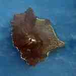
Thera
Santorini, Greece
-
Pre-Eruption Minoan Thera
Santorini, Greece
-
Spring Fresco West Wall
Swallows Scene
Akrotiri, Santorini (Thera), Greece
-
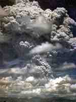
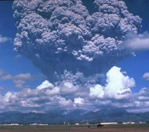
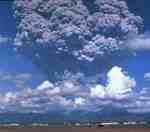
Mt. Pinatubo Eruption
Luzon, Phillipines
1991
-

Minoan Ladies in Blue Fresco
Knossos, Crete, Greece
-
Volcanic Phreatic Eruption
-
Krakatau
Sunda Strait, Indonesia
-

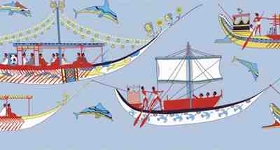
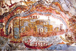
Minoan Miniature Frieze
Admirals Flotilla Fresco
Shipping Scene Restoration
West House, Room 5, South Wall
Akrotiri, Santorini (Thera), Greece
-
Mt. Pinatubo Eruption
Luzon, Phillipines
1991
-
Minoan Miniature Frieze
Admirals Flotilla Fresco
Thera Scene
West House, Room 5, South Wall
Akrotiri, Santorini (Thera), Greece
-
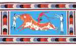
Minoan Bull Leaping Toreador Restoration Fresco
Knossos, Crete, Greece
-
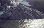
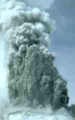
Volcanic Pyroclastic Surge
Montserat, Caribbean
1996
-

Minoan Dolphins Restoration Fresco
Knossos, Crete, Greece
-
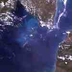
Aegean Sea
-
Anak Krakatau
Sunda Strait, Indonesia
-

Minoan Antelope Restoration Fresco
Akrotiri, Santorini (Thera), Greece
-
Anak Krakatau
Sunda Strait, Indonesia
-

Minoan Octopus Fresco
Knossos, Crete, Greece
-
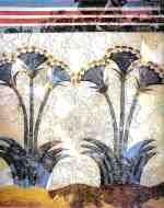
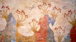
Minoan Sea Daffodils Lilies Fresco
Akrotiri, Santorini (Thera), Greece
-

Minoan Antelope Fresco
Akrotiri, Santorini (Thera), Greece
-
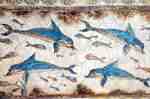
Minoan Dolphins Fresco
Knossos, Crete, Greece
-

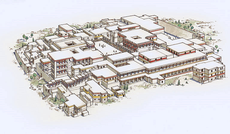
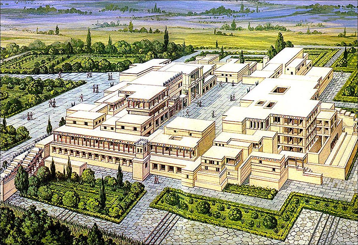
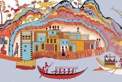
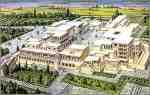
Knossos Reconstruction
Crete, Greece
-
Knossos Reconstruction
Crete, Greece
-
Krakatau
Sunda Strait, Indonesia
-

Krakatau Map
Sunda Strait, Indonesia
-

Volcanic Explosivity Index
VEI Scale
-
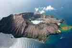
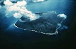
White Island Marine Volcano
New Zealand